

Farmers across the U.S. are watching the Pacific closely this year as NOAA predicts La Niña could exit faster than expected, potentially giving way to an El Niño later in 2026. While this transition could bring shifts in rainfall patterns, experts caution the change will likely be gradual, meaning parts of the country could remain dry well into spring.
NOAA is now forecasting La Niña to exit by spring and El Niño to possibly enter the picture this year, but not all meteorologists agree on the timing of that. Drew Lerner, agricultural meteorologist and founder of World Weather, says the key is when this transition takes place, and when warming ocean temperatures occur, as to how it could change weather conditions for not just planting but also the growing season ahead.
Two Weather Patterns Driving Dryness
What’s scary for farmers today is just how dry it is across parts of the West, Southwest, Southeast and Midwest. Similar to last winter, a dry fall was only exasperated by a fairly dry winter, with drought a growing threat heading into spring.
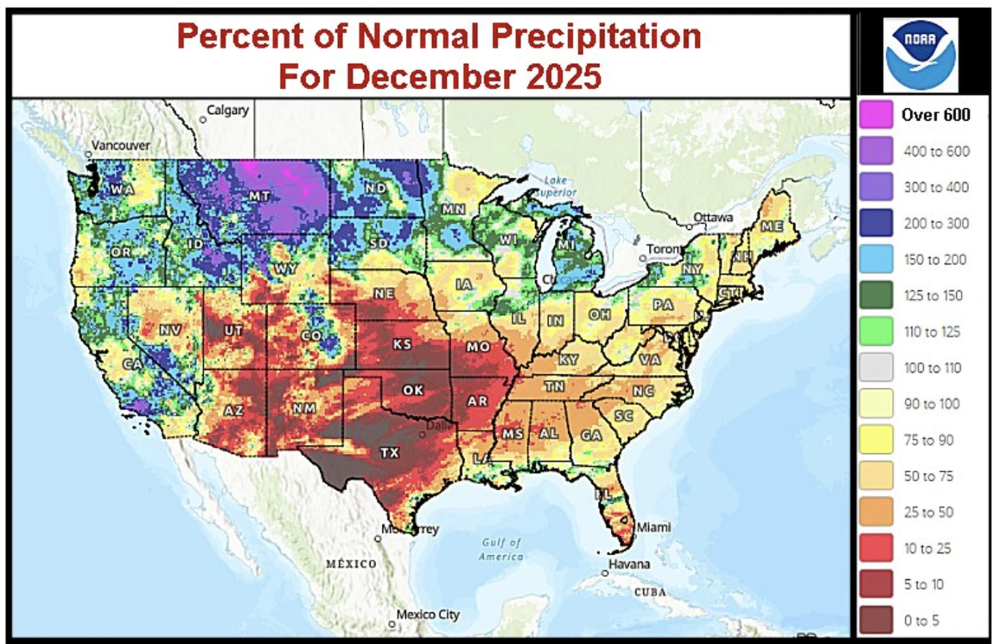
Farmers have a reason to be concerned. According to the latest U.S. Drought Monitor drought and dry conditions remain widespread across the country:
- About 35.7% of the U.S. (including Puerto Rico) is in drought (D1–D4)
- More than 42.5% of the Lower 48 is also in drought conditions
- Moderate to severe drought levels have worsened in parts of south-central Texas into Arkansas/Missouri and from Florida to Virginia over the past week
Meanwhile, California, long a drought focal point, has recently been reported as drought-free for the first time in about 25 years after significant winter storms.

What’s driving the dryness across the rest of the country? Lerner says it’s two-fold.
“We’ve actually got two major patterns at work right now,” Lerner says. “One is La Niña, which is definitely influencing the drier tendencies across the central U.S., and the other is an upper wind flow pattern tied to the lunar cycle. Together, they’re keeping cold surges coming into eastern North America and limiting rainfall across much of the Plains.”

Current soil moisture charts also show large swaths of dryness in the west-central and southwestern Plains, amplifying concerns heading into spring.
“These areas aren’t likely to get another good drink of water anytime soon; we had a little break last week, but it’s temporary,” Lerner says. “Even though the Midwest doesn’t look too bad for this time of year, much of Missouri, Iowa, Illinois, Indiana and northwestern Ohio should already have saturated soil. Still, we’re in a droughty environment.”
The Big Debate: How Quickly Will La Niña Exit?
According to NOAA models, Lerner explains, La Niña is in place but expected to exit rapidly, with a possible shift to El Niño by May.
“You can see the ocean temperatures in the equatorial Pacific are still cooler than normal,” Lerner says “To qualify for La Niña, you need roughly half a degree Celsius below normal, and that’s exactly what we have right now.”

However, he warns that the NOAA model predicting a quick exit has historically been overly aggressive, and last year was a perfect example of that.
“If you look back at the last two years, the model forecast La Niña would develop by May or June, but it didn’t actually arrive until the fourth quarter,” Lerner says. “I think the model is too warm for a rapid exit this year as well. My expectation is that El Niño won’t really show up until the latter part of the third quarter or into the fourth quarter.”
Earlier this month, NOAA issued its latest La Niña forecast, saying La Niña is likely to persist for now, but that’s followed by a 75% chance of a transition to ENSO neutral during January to March. ENSO Neutral, according to NOAA, is likely to develop in at least the northern hemisphere through late spring 2026.
“Here’s what I take away from this, and I’ve been chatting about this and other meteorologists have been chatting about this for a while,” says Brian Bledsoe of Brian Bledsoe Weather. “I have great respect for NOAA and the National Weather Service, but to be honest with you, I think they’re a little late to the party with how this transition is going to unfold because what’s going on in the Pacific Ocean right now is a pretty significant transition away from the La Niña. So I think we have seen this event peak, and I think it is going to exit more quickly than maybe what NOAA’s forecast is currently suggesting.”
Bledsoe says not only does he think NOAA is late to the party in forecasting La Niña’s departure, but he also thinks the U.S. will see a transition to El Niño faster than what NOAA currently shows.
“Initially what that can do, and what that can mean, is that transition period, it can still have some dryness produce across the Plains and across the Corn Belt, at least early on in that transition,” Bledsoe says. “History suggests that after that early transition is gone, that a lot of us will have wetter than average conditions try to show up during the heart of the growing season.”
Bledsoe says that is several months away and difficult to forecast, but he says there are different models that indicate this scenario and a quick transition can also bring wild weather.
Brett Walz Sees a Neutral Spring, Possible El Niño Summer
Brett Walz, meteorologist with Bam WX, also thinks we could be saying good-bye to La Niña in the next couple of weeks.
“I’m starting to see the shifts and getting away from La Niña probably in the next couple of weeks,” he tells “AgriTalk’s” Chip Flory. “We’ll warm the waters up and get into what we call ENSO Neutral as we work into spring. I really think that by summer we can get into an El Niño.”
Walz also notes ENSO-neutral springs often bring a mix of dry and volatile conditions.
“The back half of the season tends to see some dryness, especially in the Upper Midwest,” he says. “May 2023 was a very dry month leading into planting and the start of the growing season, and I see some similarities here. Before that, March and early April could be a little volatile, with some ups and downs and even early-season severe weather.”
Implications for Spring Planting
For U.S. farmers, the combination of lingering La Niña effects and a transitional ENSO-neutral spring could mean dryness persists in critical growing regions through spring.
“Parts of the central U.S., especially the western Corn Belt and hard red winter wheat areas, are going to see below-normal precipitation during spring,” Lerner says. “The Delta and lower Midwest may do a little better, but overall, we’re looking at a spring that won’t dramatically relieve the dryness farmers have been dealing with.”
He points out analogs from past ENSO years support this outlook, but then the forecast flips to more moisture in summer for more northern states, with dryness parked in the South.
“Three of the four years I’ve analyzed moved from La Niña into neutral conditions through early summer, then transitioned to a weak El Niño later,” Lerner says. “We generally see a wetter bias in the northern Plains and parts of the Midwest in summer, while the Southeast may fall back into drier conditions after a brief spring break.”
“If we were to suddenly shift into El Niño, we’d see more rainfall in the Plains and western Corn Belt during spring,” he adds. “But given the history of these forecast models, it’s unlikely we’ll see a dramatic shift until later this year.”
___________________________________________________________________________________________________
Summer Outlook: A Mixed Picture
Looking ahead, both Lerner and Walz see the potential for wetter conditions later in the growing season:
- Northern Plains and parts of the Midwest could see above-average precipitation in summer
- Southeastern U.S. could experience drier conditions after a brief spring respite
- The western Corn Belt and hard red winter wheat regions will likely remain dry through spring
___________________________________________________________________________________________________
Impacts on South America’s Weather
Walz says these ENSO shifts have global implications, particularly for South America.
“There’s a lag in how La Niña affects South America, because their growing season is opposite ours,” he says. “Currently, we’re still seeing dryness across Argentina and Southeast Brazil, but as La Niña weakens, we may start getting rains back into Brazil, especially by the back half of February.”
But up until this point, Lerner says La Niña isn’t having much of an impact on South America’s weather, which he says is a byproduct of the very weak status of the current La Niña event.
“And if you look at the soil assessment there in Brazil and Argentina, you can see the moisture profile is really not too bad,” Lerner says. “Now we are starting to dry out portions of Buenos Aires and some of the neighboring areas there in Entre Rios and southern Santa Fe, even southern Cordova, and we do to see some significant moisture in these areas.”

He points out just last week some of the computer forecast models were trying to generate a La Niña-like ridge of high pressure over Argentina through these next 10 days.
“And if that happens, we will continue to dry down Argentina, but more so in the east rather than the south, and it will go ahead and spread a little bit into southern Brazil,” Lerner says. “But, as far as La Niña events is concerned, this one has not brought much dryness to South America, and most of the South America crops, up until now, have been doing very well.”
He says if La Niña does dissipate in February, then it’s going to probably start raining again in these drier biased areas.
“I think that this short-term bout of ridge development and drier bias conditions in Argentina, Brazil, will not likely last long enough to have a big impact on the bottom line,” he adds.
What U.S. Farmers Need to Know Going Forward
Spring 2026 could bring a mix of dryness, volatility and early-season severe weather in key U.S. crop areas. Irrigation management and soil moisture monitoring will be critical. Farmers should also keep an eye on South American conditions, which influence global markets, especially for soybeans and corn.
“Farmers shouldn’t rely on a sudden shift to El Niño to solve moisture deficits,” Lerner emphasizes. “Prepare for continued dry spells in spring, and be ready to take advantage of wetter periods later in the year if they arrive.”
Walz adds: “This spring will be ENSO-neutral, a transitional period, but summer could bring a true El Niño — something that isn’t common but could have significant implications for rainfall patterns and planting decisions.”