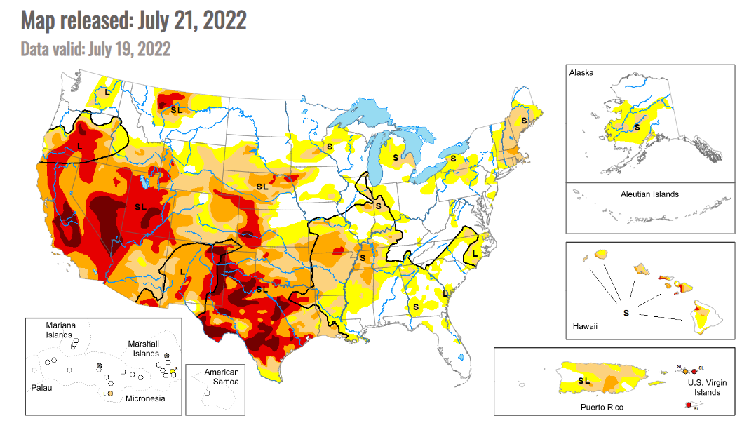
Drought coverage unchanged but footprint shifts

As of July 19, 69% of the U.S. was experiencing abnormal dryness/drought, according to the U.S. Drought Monitor, unchanged from the previous week. But there was some movement of the drought footprint based on areas that received/didn’t receive rains. The Drought Monitor commentary stated, “Most of the eastern third of the U.S. recorded precipitation during the last week, with only a few pockets that missed out. Portions of the Midwest and into the Southeast had some amounts over 3 inches for the week and even widespread 5+ inch amounts in the coastal areas of Florida, and some rain at the end of the period allowed for much of New England to stay status quo for the week and even see a few improvements. The areas with the most rain also had the coolest temperatures, with much of the Midwest and Southeast cooler than normal for the week with departures of 2-4 degrees below normal. Warmer-than-normal temperatures dominated the western half of the country with areas from Montana to Texas recording temperatures that were 6-8 degrees above normal. The coastal areas of the Pacific Northwest were cooler than normal while the Great Basin was warmer than normal with departures of 6-8 degrees above normal. With the dryness and heat, the flash drought that has been developing in the central to southern Plains developed even more this week with the wet conditions of May and June quickly being forgotten.”
For the Midwest, the Drought Monitor commentary noted: “Another week where most of the eastern portions of the region recorded above-normal precipitation, with the greatest amounts through Kentucky, southern Illinois, southern Indiana and northern Ohio as well as in portions of northern Wisconsin. Temperatures were 1-3 degrees below normal in these areas of greatest precipitation, with the coolest readings over eastern Wisconsin and northern Ohio. Warmer-than-normal conditions were recorded from Minnesota to Missouri, where flash drought conditions continue to develop in the southern half of the state. Missouri had widespread degradation this week with most of the southern half of the state experiencing a full category degradation on the U.S. Drought Monitor. Severe drought expanded over western Kentucky while moderate drought expanded over central Minnesota. New areas of moderate drought were introduced into southeast Iowa and Michigan while a new area of severe drought was introduced into central Minnesota. Improvements were made to moderate drought and abnormally dry conditions over Illinois, Indiana, and Kentucky, with just a slight expansion of severe drought in eastern Illinois. Heavy rains over portions of northern Wisconsin allowed for improvements to moderate drought and abnormally dry conditions.”
Across the Plains, the commentary stated: “A warm and mainly dry week dominated the region. Temperatures were warmest in eastern Montana and from western North Dakota to western Kansas, where departures were 6-8 degrees above normal. There were some pockets of very intense rains in Nebraska, North Dakota and eastern Colorado, but widespread rains were minimal. South Dakota had expansion of abnormally dry and moderate drought over much of the southern tier of the state while eastern Kansas had widespread introduction of abnormally dry conditions and moderate drought expansion. Severe and extreme drought expanded over much of western Kansas while severe drought expanded over north-central Nebraska and in the panhandle. Severe drought also expanded on the plains of eastern Colorado and extreme southeast Wyoming. There was a slight improvement in extreme drought in northeast Nebraska where some intense rains fell in the middle of the previous extreme drought area.”
Across the Corn Belt, dryness/drought covers 36% of Illinois (down 17 points), 69% of Indiana (down 10 points), 47% of Iowa (up 2 points), 82% of Kansas (up 22 points), 41% of Michigan (up 1 point), 28% of Minnesota (up 17 points), 74% of Missouri (up 11 points), 87% of Nebraska (unchanged), 1% of North Dakota (up 1 point), 16% of Ohio (down 4 points), 59% of South Dakota (up 4 points) and 35% of Wisconsin (unchanged).
USDA estimates the drought footprint at 29% for corn (down 1 point from last week), 26% for soybeans (up 1 point), 16% for spring wheat (down 1 point) and 66% for cotton (down 5 points).