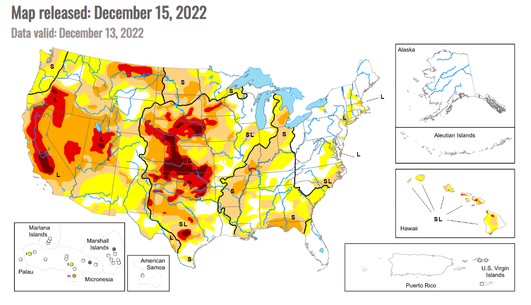
Drought recedes a little more, but footprint still wide

As of Dec. 13, 78% of the U.S. was experiencing abnormal dryness/drought, according to the U.S. Drought Monitor, down one percentage point from the previous week and seven points below the peak at the beginning of November.
USDA estimated 71% of the winter wheat crop was experiencing drought, down two percentage points from the previous week but 18 points greater than last year at this time.
In HRW areas, dryness/drought covers 84% of Colorado (unchanged), 100% of Kansas (unchanged), 88% of Montana (unchanged), 100% of Nebraska (unchanged), 98% of Oklahoma (down 2 points), 100% of South Dakota (unchanged) and 75% of Texas (up 1 point).
In SRW areas, dryness/drought covers 75% of Missouri (down 6 points), 86% of Illinois (unchanged), 93% of Indiana (unchanged), 52% of Ohio (down 5 points), 49% of Michigan (up 8 points), 79% of Kentucky (down 19 points) and 51% of Tennessee (down 46 points).
In the South, the Drought Monitor noted: “In northern parts of the region, from central and eastern Oklahoma eastward through Tennessee, widespread moderate to heavy rain fell, leading to widespread improvements to ongoing drought and abnormal dryness. In central Oklahoma and north Texas, given that some of this rain fell near the data cutoff, more changes may be made next week as more data becomes available. Wetter recent weather led to improvements in surface conditions and precipitation deficits in central and west-central Texas, leading to some improvements in ongoing drought there. Due to recent heavy rainfall, severe drought areas in southwest Arkansas and near the Louisiana/Mississippi border were removed. A few localized spots in the eastern half of Texas saw conditions worsen after missing out on recent rains. Most of the region saw above-normal temperatures this week, with large portions of central and eastern Texas, Louisiana, and Mississippi seeing readings at least 15 degrees above normal.”
Across the Plains, the Drought Monitor noted: “Heavier rains accumulated Monday night into early Tuesday in parts of southeast Kansas, leading to some improvements in the drought situation there as precipitation deficits lessened. Dry weather continued in parts of northwest Kansas, where soil moisture deficits and long-term precipitation deficits continued to worsen. A few small changes (one improvement and one degradation) were made in southeast Colorado and adjacent northeast New Mexico, where surface conditions changed in tandem with recent precipitation or lack thereof. Elsewhere, conditions did not change much across the region. Snow and rain that fell Monday night and Tuesday morning from northeast Colorado into Nebraska and southern South Dakota will be analyzed further next
week for possible improvements to ongoing drought. Temperature anomalies for the week varied from north to south across the region, with below-normal temperatures occurring in most of North Dakota, while near- or slightly above-normal temperatures were more common in Colorado and Kansas.”
For the Midwest, the Drought Monitor noted: “Conditions varied widely across the Midwest region this week. Short-term dryness continued in parts of Indiana, Ohio, and Illinois, where recent precipitation mostly missed to the south and west before Tuesday morning. Severe short-term drought developed in southeastern parts of the Michigan Lower Peninsula, where soil moisture and precipitation deficits mounted, and reports of groundwater problems emerged. Meanwhile, in the southern tier of the region, from southern Missouri eastward through Kentucky, widespread moderate to heavy rain led to widespread improvements to ongoing drought and abnormal dryness, with most of southwest Missouri and almost all of Kentucky seeing a one-category improvement to conditions. An early-week storm system deposited both rain and frozen precipitation in Iowa and other parts of the Upper Midwest near the Tuesday morning data cutoff. A small reduction in extreme drought coverage was made just northeast of Sioux City, Iowa, where higher amounts of precipitation fell. Across the rest of the region that experienced significant precipitation on Monday night and Tuesday, further analysis will occur next week. More improvements may be made next week if the wider suite of data is supportive when it becomes available.”