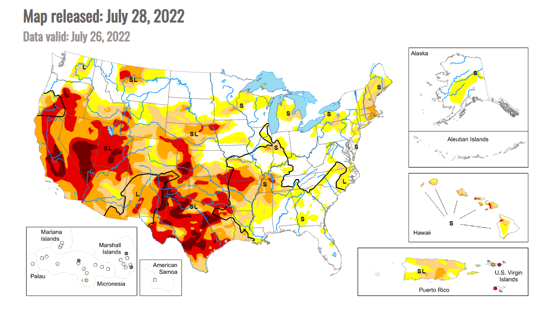
Drought footprint largely unchanged but conditions intensified in key areas
As of July 26, 68% of the U.S. was experiencing abnormal dryness/drought, according to the U.S. Drought Monitor, down one percentage point from the previous week. But the Drought Monitory summary noted: “Drought persisted across much of the West this week, while flash drought over parts of the Great Plains, Ozarks, and Mississippi Valley continued to intensify and cause agricultural problems... Conditions locally improved in parts of the Southwest due to an influx of rainfall from the North American Monsoon. Farther east into the lower Great Plains and Midwest, localized heavy rainfall led to improvements, including severe flooding in the St. Louis Metro area, which previously had been experiencing abnormally dry conditions.”
For the Midwest, the commentary stated: “The Midwest saw a mix of degradations and improvements in the Drought Monitor this week, after weather was highly variable across the region. Hot and dry weather covered south-central and southwest Missouri, where flash drought continued to intensify and agricultural problems continued as a result. Just to the north of this region, heavier rains fell in two areas, one from southeast of Kansas City to southeast Missouri, and a second in central, eastern, and northeast Missouri. The latter caused flash flooding in the St. Louis area and a record one-day rainfall at St. Louis Lambert Airport. Both areas of heavy rain set up tight north-to-south gradients in drought and abnormal dryness conditions in Missouri. Improvements to the drought situation occurred in parts of northeast Illinois, though heavier rains missed the severe drought area centered near Champaign. Drought expansion paused this week in the Michigan Lower Peninsula where widespread rain fell. Localized improvements were made in parts of Indiana, Ohio, and Kentucky where short-term conditions improved due to heavy rainfall. A mix of improvements and degradations occurred in Minnesota and Wisconsin around areas where heavier rain fell. Soil moisture deficits continued to mount in far northern Wisconsin, where moderate drought developed.”
For the Plains, the commentary noted: “With the exception of Colorado (which was mostly warmer than normal) and southern Kansas (which was 4-8 degrees warmer than normal), temperatures in the High Plains region this week were generally within 2-4 degrees of normal. Rainfall from the North American Monsoon occurred in parts of southern, central, and eastern Colorado, locally easing drought conditions in the eastern part of the state. Heavy rains in south-central and southwest South Dakota, and in southern Nebraska, northern Kansas, and east-central Kansas, led to locally improved drought and dryness conditions. Meanwhile, south of the heavier rains, flash drought continued to take hold in southern Kansas, where a combination of dry and hot weather worsened conditions. Extreme drought expanded in parts of southwest Nebraska, where short- and long-term precipitation deficits worsened conditions amid poor crop health. Drought also expanded in northeast Nebraska and southeast South Dakota, where soil moisture deficits continued to mount amid warm temperatures and dry weather. Extreme drought also developed in western Wyoming, where above-normal evaporative demand combined with short-term precipitation deficits to worsen conditions locally.”
Across the Corn Belt, dryness/drought covers 29% of Illinois (down 7 points from last week), 50% of Indiana (down 19 points), 56% of Iowa (up 9 points), 81% of Kansas (down 1 point), 46% of Michigan (up 5 points), 30% of Minnesota (up 2 points), 66% of Missouri (down 8 points), 89% of Nebraska (up 2 points), 1% of North Dakota (unchanged), 9% of Ohio (down 7 points), 59% of South Dakota (unchanged) and 46% of Wisconsin (up 11 points).
USDA estimates the drought footprint at 29% for corn (unchanged from last week), 26% for soybeans (unchanged), 16% for spring wheat (unchanged) and 70% for cotton (up 4 points).